

These maps and the many cleanups, community events, and trail programming are made possible by the Friends of the Trail - consider contributing for only $25 per year!
Trail Notices & Closures
The DNR posts notices on their website. For general winter trail conditions regarding snow/ice removal, view the Trail FAQs. Learn more about enjoying the Trail during winter.
Digital Map
There is a lot to see on the Trail, so we recommend opening the digital map in Google Maps (also works on your mobile device) so you can turn on and off layers depending on how you want to experience the Trail. You can also click on icons to learn more about that location.
Fixit Stations & Bike Shops
Bublr Bike Stations
Popular Destinations on the Trail
Informational Signs & Kiosks
Trail Access Points & Trail Connections
Parking & Restrooms
Public Art
Zoom in and out using the wheel on your mouse. If you don’t have a wheel, double click on the left side of the mouse to zoom in and double click on the right side of the mouse to zoom out. Move the map around by holding down the left cursor and moving the map. Do you have feedback on the map? Let us know.
A big thank you to Dennis Meilicke, software architect and developer, who offered his services pro bono to create this digital map.
Trail Maps (PDF Format)
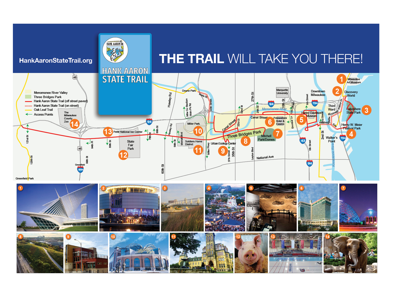
Find your own path or arrive at some of Milwaukee's most popular destinations using the map below. The Trail will take you There!

trail map
This is a large trail map, however it is not printer-friendly. You can pick this map up at informational stands along the trail.
Updated: 2.26.21

printable map
This map is appropriately sized for printing onto three pages.
Updated: 2.26.21

mapa del sendero en espanol
Este mapa está en español.
Updated: 11.20.18
“I take the Hank Aaron State Trail to work, and to the lake, the ballgame, State Fair, or just to a neighborhood for lunch. This trail is a great connector.”
Video Tour of the Trail
In September 2019, Lori Nickel of the Journal Sentinel took video of her ride along the trail. This is a great intro to the Trail! See the accompanying article, Chin Up: Joy riding through Milwaukee on the Hank Aaron State Trail.
Popular Destinations Along the Trail
Connecting Trails
The Hank Aaron State Trail provides a key link through the heart of Milwaukee County, including the Menomonee Valley and Third Ward. Starting at Lakeshore State Park along Lake Michigan to the western border of Milwaukee County, the Trail provides a link that makes it possible to bike from Lake Michigan, along several trails across the state. Eventually these trails will link together with the Ice Age National Scenic Trail and Military Ridge State Trail, with one goal being to create a continuous trail from Lake Michigan to the Mississippi River.
The Trail map and digital trail map shows where you can connect to other trails.

On the west end of the Trail, you can connect to the Oak Leaf Trail, New Berlin Trail, West Allis Cross Town Connector, and the Brookfield Greenway Trail. Photo: Marcy Berenschot
For more information on connecting trails, see the following pages:
Milwaukee by Bike
This comprehensive website is maintained by the City of Milwaukee and provides information about cycling in Milwaukee, including bike lanes and routes, bike registration, area bike shops, the Bicycle and Pedestrian Task Force, maps, safe biking tips, and more. There are lots of links to other wonderful cycling websites, as well.

Oak Leaf Trail
The trail features over 100 miles of multiple loops through all the major parkways and parks in the system. Loops are composed of off-road paved trails, park drives, and municipal streets where necessary to ensure continuity.
Waukesha County Park System
The Waukesha County Park System provides nearly 30 miles of trails, including the New Berlin Trail which connects to the Hank Aaron State Trail.
For more information on cycling:
Wisconsin Department of Natural Resources
The Department of Natural Resources is dedicated to the preservation, protection, effective management, and maintenance of Wisconsin's natural resources. It is responsible for implementing the laws of the state and protecting the natural resources of our state.
Wisconsin Department of Transportation Bicycle Information
WisDOT provides information about state bicycling facilities, state statutes that relate to bicycling, the state bike plan 2020, and downloadable bike maps for the entire state county-by-county.
Wisconsin Bike Fed
The Wisconsin Bike Fed is a statewide, nonprofit, bicycle advocacy organization with thousands of members that works to make Wisconsin a better place to bicycle.

League of American Bicyclists
The league of American Bicyclists promotes bicycling for fun, fitness and transportation and work through advocacy and education for a bicycle-friendly America. At this website you’ll find lots of terrific bicycling resources.
Ozaukee Interurban Trail
The Ozaukee Interurban Trail is a 30-mile paved trail that spans the entire length of Ozaukee County. The Trail connects the Ozaukee communities of Mequon, Thiensville, Cedarburg, Grafton, and Port Washington.

Wisconsin Bicycle Routes
Maintained by Bruce Thompson, a comprehensive website listing trails and road routes throughout Wisconsin and neighboring states.
Historically, workers from the Silver City neighborhood got to work in the Valley by passing under railroad tracks through a tunnel, then crossing the river by bridge. When the bridge was removed and the tunnel sealed decades ago, south side neighbors had to travel nearly three miles to get to jobs and recreation in their backyards. Once the Valley Passage bridge was complete, residents could again access jobs or park space with a two block walk.
What's in a Name?
The Trail is named after Hank Aaron, a Major League baseball player who broke many racial and cultural barriers. The Trail, which connects the diverse neighborhoods of the greater Milwaukee community, exemplifies his legacy.
